

15 Best Hikes Near Bluemont, Virginia
There are more than a few engaging and scenic hikes near Bluemont, which is located at Snickers Gap (Route 7) in Loudoun County, Virginia.

Whether you want to hike across a former battlefield, along the white-blazed Appalachian Trail or beside a gently-flowing river, this area is tops for hikers.
Bluemont area hikes wow with scenic vistas, rock scrambles and hiker shelters, even waterfalls. You can’t go wrong with Bluemont’s hiking trails.
Hikes Near Bluemont, Virginia
To make it a snap to navigate, I’ve grouped hikes by difficulty level so you know what to expect before stepping foot on the hiking trails.
For each of the hikes below, I also share what’s to love and how far they are from Bluemont. From Bluemont General Store, to be exact.
Easy Hikes
For an easy-going walk in the woods, alongside a river or across a one-time golf course, these easy hikes in and around Bluemont do not disappoint.
#1: Bears Den Overlook (5 mins)

The kid-friendly hike to Bears Den Overlook guides hikers along a delightful, shady stretch of the white-blazed Appalachian Trail in Bluemont.
But first, plan to hike along a .3-mile blue-blazed spur trail from the large parking area to connect with the Appalachian Trail for the Bears Den hike.
From here, it’s a short walk to the exceptionally scenic Bears Den Overlook. Get ready to navigate tree roots, boulders, wildflowers and rocky terrain on this hike.
#2: Cool Spring Battlefield (10 mins)

It’s not often you get to hike across land that was once a golf course and a Civil War battlefield. To boot, you’ll even see a small waterfall on this hike.
At Shenandoah University’s Shenandoah River Campus at Cool Spring Battlefield in Bluemont, two paved loops lure in visitors for quiet reflection.
The loops are actually golf cart paths from the one-time Virginia National Golf Course. The scenic 18-hole golf course closed up and was abandoned in 2012.
#3: Ball’s Bluff Battlefield (25 mins)

There are seven hiking trails at Ball’s Bluff Battlefield Regional Park in Leesburg, including a section of the 710-mile Potomac Heritage National Scenic Trail.
This regional park sits on the site of the Battle of Ball’s Bluff, a Civil War clash on a bluff overlooking the Potomac River that took place on October 21, 1861.
Battlefield interpreters lead tours that range from introductory (45 mins) to in-depth (90 mins) on the history of this bloody battle between North and South.
#4: Blue Ridge Center (25 mins)

The Blue Ridge Center for Environmental Stewardship is home to 10 miles of wooded hiking trails. It’s also on track to be the future Sweet Run State Park.
At the Blue Ridge Center, 14 short trails range in length from .1 miles to 1.9 miles. It’s easy to add or subtract steps to create-your-own Virginia hike, too.
The Blue Ridge Center’s website highlights four suggested hikes, including Farmstead Loop, Legacy Loop, Butterfly Alley and Birds of the Ridge.
#5: Red Rock Overlook (25 mins)

At Red Rock Wilderness Overlook Regional Park in Leesburg, the 1.2-mile loop hike around this 67-acre park is a must-do for water views and wooded trails.
At this small forested park, there are winding nature trails, as well as historic buildings from the 1880s, including a Carriage House and an Ice House.
The property dates to 1869 when a wealthy industrialist purchased 2,000 acres in Loudoun County. This section was donated in 1978 for use as park land.
Moderate Hikes
These moderate hikes near Bluemont are between three and eight miles. There’s more elevation, but also waterfalls, sweeping vistas and rock scrambles.
#6: Raven Rocks (5 mins)

One of the most popular hikes near Bluemont is the 5.1-mile out-and-back trek to Raven Rocks along a stretch of the iconic Appalachian Trail.
It’s a rocky climb with an elevation gain of more than 1,500 feet that generously rewards your efforts with far-reaching valley and mountain views.
The Raven Rocks hike winds along a rock-laden section of trail. You may bump into a thru-hiker or two, depending on the time of year you hike the trail.
#7: Buzzard Hill (15 mins)

The wooded 3.5-mile out-and-back hike to Buzzard Hill wows with a creek crossing (Hollow Brook), a small waterfall and westerly views from Buzzard Hill.
Near the top, you will see a primitive campsite with a fire ring, but press on. The far-reaching views are only a few more steps further up the trail.
At the 1.7-mile mark, keep your eyes open for a short spur trail on the left. This will swiftly guide you to the west-facing overlook at Buzzard Hill.
#8: David Lesser Shelter (20 mins)
The hike to the David Lesser Shelter on the Appalachian Trail begins at Keys Gap, which straddles the state line between Virginia and West Virginia.
There are scenic views on this hike, but they are best viewed from late-fall to early-spring when there are no leaves. You can also see working farms in Hillsboro.
The star of this hike near Harpers Ferry is the David Lesser Shelter, which has a small campground. Continue past the shelter to savor Buzzard Rocks View.
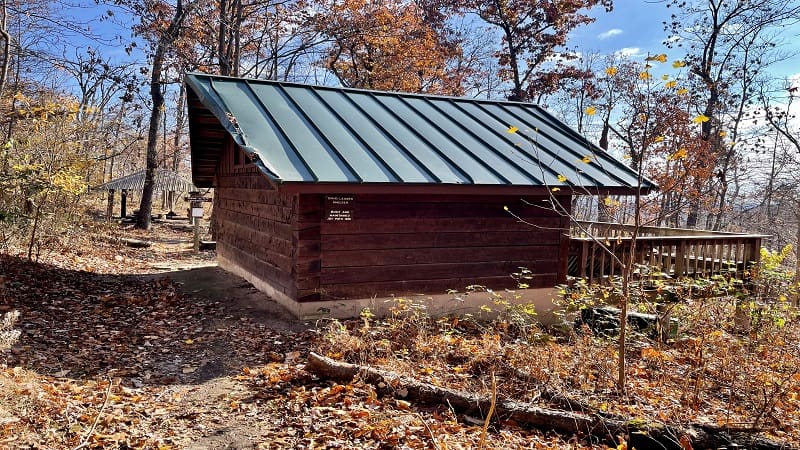
#9: Myron Glaser Cabin (20 mins)

Myron Glaser Cabin is one of a few dozen primitive Potomac Appalachian Trail Club (PATC) cabins for rent in Virginia, Maryland, West Virginia and Pennsylvania.
Most hike-in cabins, like Range View Cabin, can be rented by anyone. Some cabins, like Myron Glaser Cabin, are reserved for PATC members only.
This 4.5-mile out-and-back hike begins from a parking area off Blue Ridge Mountain Road, near Route 50. Note, the “Trailhead Parking” sign is very small.
#10: Lost Mountain (25 mins)

Set in northwest Fauquier County, Sky Meadows State Park is a wonderfully scenic state park split into two sections by U.S. Route 17 (Winchester Road).
The east section is home to the more pastoral Lost Mountain Trails. The Lost Mountain and Rolling Meadows Trails form a relaxing and serene hiking loop.
It’s a beautiful 4.0-mile hike, but also a quiet hike. Most visitors set off on west section trails for wide-open scenic overlooks and the Appalachian Trail.
#11: Old Trail Loop (25 mins)

The quiet, wooded Old Trail Loop hike includes both the Appalachian Trail and Old Trail, a hiking trail that was a short section of the AT from 1983 to 2004.
In 2004, the Appalachian Trail was re-routed to its current route through Sky Meadows State Park. Old Trail became a part of the state park trail system.
Thanks to more than 20 miles of hiking trails at Sky Meadows State Park, it’s easy to make this hike longer by adding on trails, like the North Ridge Trail.
#12: South Ridge-North Ridge Loop (25 mins)

Let me first note that I tackled this 3.5-mile loop at Sky Meadows State Park in the wrong direction. Trust me, you want to complete this hike clockwise.
Clockwise, you’ll ascend the South Ridge Trail, then descend the North Ridge Trail. This way, pastoral views across Fauquier County will be front and center.
On this hike, you will pass several wooden benches to take a seat and enjoy the vistas, as well as the Snowden Manor Ruins Site, which includes a stone fireplace.
#13: Piedmont Overlook (25 mins)

One of the most popular scenic overlooks at Sky Meadows State Park is divided in two overlooks – Lower Piedmont Overlook and Upper Piedmont Overlook.
Both can be reached quickly (but be ready for a healthy ascent) along the Piedmont Overlook Trail, which sets off near the Park Office.
Re-trace your steps once you’ve savored the overlooks or continue on to the Ambassador Whitehouse Trail for more views from Whitehouse Overlook.
Strenuous Hikes
For a challenging hike, hit the Appalachian Trail hikes toward backpacker shelters near Bluemont. Don’t forget to bring plenty of water.
#14: Sam Moore Shelter (5 mins)

The Sam Moore Shelter for hikers and backpackers is located on the famed Roller Coaster section of the Appalachian Trail in Northern Virginia.
This hike shares a starting point with the Bears Den Overlook hike, but once you pass the scenic overlook, get ready for ups and downs, ups and downs.
The overall elevation gain on this hike to see the Sam Moore Shelter exceeds 2,000 feet. It’s a very good workout. It’s tough, but not vicious. You can do this.
#15: Rod Hollow Shelter (15 mins)

The Rod Hollow Shelter is also located on the famed 13.5-mile Roller Coaster section of the Appalachian Trail, which runs from Snickers Gap to Ashby Gap.
This wooded southbound hike begins on the opposite side of Morgans Mill Road from the Buzzard Hill hike. The two share a good-size parking area.
Plan to cross a wooden footbridge over Ashby Hollow, then go up and down, up and down to reach the Rod Hollow Shelter, as well as several tent pads.

Erin Gifford has completed more than 300 hikes in Virginia. She is also the author of three hiking guidebooks from Falcon Guides. Need help finding a hike? Check out the Trail Finder feature or send Erin an email at [email protected].


