Humpback Rocks Hike: Trail Guide, Parking & Route Options
Humpback Rocks is a short but strenuous hike near milepost 5.8 on the Blue Ridge Parkway in Virginia.
The most popular route is a 2-mile out-and-back hike that climbs 700 feet in one mile to a rocky overlook above the Shenandoah and Rockfish valleys.

| Humpback Rocks Out-and-Back at a Glance | |
|---|---|
| Length | 2.0 miles |
| Difficulty | Strenuous |
| Trail Type | Out-and-back |
| Elevation Gain | 700 feet |
| Duration | 1.5-2 hours |
| Terrain | Mostly dirt & rock trails, some steps & rock scrambles |
| Dog-Friendly | Yes |
| Fee | Free |
| Best For | The shortest route to and from the overlook |
| Driving Directions | Click Here |
For a longer hike with a more gradual descent, hikers can also complete a 4.3-mile loop hike using the Appalachian Trail.
Arrive early because the small Humpback Gap parking lot fills quickly, especially on weekends and during fall foliage season.

| Humpback Rocks Loop at a Glance | |
|---|---|
| Length | 4.3 miles |
| Difficulty | Strenuous |
| Trail Type | Loop |
| Elevation Gain | 1,099 feet |
| Duration | 2.5-4 hours |
| Terrain | Mostly dirt & rock trails, some steps & rock scrambles |
| Dog-Friendly | Yes |
| Fee | Free |
| Best For | Fewer crowds and a less abrupt descent |
| Driving Directions | Click Here |
A third way to go would be longer still, an out-and-back hike that clocks in at 6.6 miles.
This third route avoids the popular and steep section to the summit, instead traversing the Appalachian Trail to and from Humpback Rocks.

A friend and I chose the 4.3-mile counter-clockwise loop via the Appalachian Trail. The return trip from the summit to the parking lot was more manageable.
Not only was the return hike less steep, but we encountered fewer people on the Appalachian Trail on the way to the parking area.
Humpback Rocks Hiking Trail
While the summit hike is the most popular, there are several other Humpback Rocks hiking trails that set off in the area near the Humpback Rocks Visitor Center.
The hike to Humpback Rocks begins from the Humpback Gap Overlook parking area at milepost 5.8. There are parking spaces for only a couple dozen cars.

We arrived by 8 am on a Friday in October and were able to nab one of the last spaces. When we returned to the lot post-hike, there were many, many more cars.
At the parking area, you’ll find at least one picnic table and several porta-potties just steps from the trailhead.
Humpback Rocks Hike
I’ll walk through the loop hike below, though the first one mile is the same whether you choose the loop hike or the out-and-back route.
From the parking area, look for a large trail kiosk. It’s to the left of the porta-potties. You’ll see a steep trail just past the sign. This is the start of the hike.
Dig deep and begin to follow the blue blazes. You’ll pass three or four benches on the way up the trail. Then, a set of wooden steps.

At the 0.55-mile mark, you will reach at least two dozen steps before you can continue this blue-blazed trail. Keep your mind occupied with the scenic beauty.
From here, the hike gets a bit more precarious as you encounter some rocky steps and rock scrambles.
Then, you know, more steps before reaching a trail sign. At last, Humpback Rocks is a mere 800 feet to the left on the trail.
Summit Views
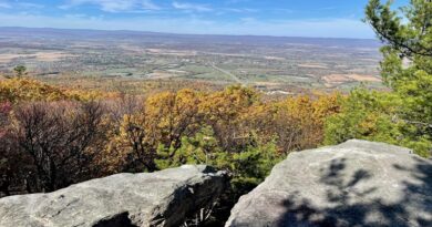
Get ready for spectacular views across Virginia’s Shenandoah Valley. The rocky outcrops at Humpback Rocks are plentiful.
But then again, so are the number of hikers on a busy day on the mountain.

Take time to savor the great views from this prominent rock outcrop. To the north, you can see the southern section of Shenandoah National Park.
Once you soak in all the scenery, re-trace your steps to the trail sign. Here, you can turn right for a direct route back to your car for an out-and-back hike.
Alternatively, walk past this sign for the Humpback Rocks Trail. This is a short spur trail that leads to the white-blazed Appalachian Trail at the 1.3-mile mark.

Turn left at the next trail sign onto the AT. On the way down this northbound section of trail, you’ll encounter more than a dozen switchbacks.
It’s a fairly uneventful hike through thick woods along the Appalachian Trail, but it was less-trafficked and rather quiet, which was a delight on a fall morning.
At the 3.5-mile mark, stay to the left when the AT rubs up against another trail. Then, at the 4.0-mile mark, veer left again to stay on the Appalachian Trail.

In less than 0.3-mile, you will close the loop and arrive at the back of the Humpback Gap Overlook parking area. Your hike is complete, so celebrate.
From the Humpback Rocks parking area, the loop hike took us nearly 2.5 hours, including time to settle in for a snack with a view atop Humpback Rocks.
We completed this hike mid-morning, but this is a fantastic sunrise or sunset hike, thanks to 360-degree views from the summit. Bring a headlamp for safe hiking.

What to Know Before Hiking Humpback Rocks
The Humpback Rocks hike rewards with 360-degree views, but you’ll want to arrive prepared. Here’s what you need to know.
How long is the Humpback Rocks hike?
The shortest route is approximately two miles round trip. A longer loop using the Appalachian Trail is approximately 4.3 miles.
Which Humpback Rocks route should I take?

The short out-and-back is the quickest and most popular, but the descent is steep. The loop descends more gradually along a series of switchbacks.
Is Humpback Rocks a difficult hike?
Yes. The direct route is short but strenuous, climbing roughly 700 feet in about one mile over steep, rocky terrain.
Where can I park for Humpback Rocks?
Park at the Humpback Gap parking area at milepost 5.8 on the Blue Ridge Parkway. Do not confuse it with the nearby visitor-center parking area.
How long does it take to hike Humpback Rocks?

Most hikers should allow approximately 1.5 to 2 hours for the short out-and-back, including time at the overlook. The longer loop generally takes 2.5 to 4 hours.
Are dogs allowed at Humpback Rocks?
Dogs are generally allowed on Blue Ridge Parkway trails but must comply with current NPS leash and pet regulations. Check official rules before visiting.
Is Humpback Rocks good for sunrise?
Yes, but hikers starting before daylight should carry a headlamp and use extra caution on the steep, rocky trail and exposed summit.
Are there restrooms at Humpback Rocks?

There are several porta-potties steps from the trailhead. Restrooms may also be available seasonally at the visitor center.
Humpback Rocks Visitor Center
Stop in the Humpback Rocks Visitor Center at milepost 5.8 on the Blue Ridge Parkway. There is a mountain life museum and a historic farm.
The easy 0.25-mile Mountain Farm Trail guides visitors through an outdoor museum designed to look like an 1890s mountain farm.
In summer months, costumed interpreters showcase Appalachian mountain life at the start of the 20th century.
The farm features a cabin, chicken house, barn, pig pen and spring house.
You’ll also learn how Humpback Rocks served as a guidepost for settlers traveling in wagon trains on the old Howardsville Turnpike in the 1840s.
Humpback Rocks Picnic Area
A few miles down the byway, at milepost 8.5, you’ll find the Humpback Rocks picnic area. There are plenty of picnic tables and green space.

You can also access the short 0.3-mile Catoctin Trail from the picnic area. This leg stretcher hike leads to the Greenstone Overlook with west-facing valley views.
Nearby Hikes
Here are a few more hikes you may want to consider after you hike the Humpback Rocks Trail:
#1: Jack Albright Loop

The 3.8-mile hike on the Jack Albright Loop (also known as Dobie Mountain) shares the Humpback Gap parking area with the Humpback Rocks hike.
The Glass Hollow Overlook at the 1.0-mile mark (counter-clockwise) wows with panoramas of the Rockfish Valley. Also, the remains of a 1960s plane crash.
#2: Dripping Rock South

The short Dripping Rock South hike originates across the Blue Ridge Parkway from the Dripping Rock parking area at milepost 10 on the Blue Ridge Parkway.
The 2.8-mile out-and-back hike guides hikers along a forested southbound section of the Appalachian Trail. Along the way, plan to be wowed by two scenic overlooks.
#3: Crabtree Falls

In Montebello, Crabtree Falls is a stunner for its dramatic cascades and rewarding views across the Blue Ridge Mountains from the top of the 1,214-foot-tall falls.
This waterfall wows with five tumbling cascades that are within view nearly every step of this 1.7-mile hike (one-way) to the top along Crabtree Creek.
Ready for another great hike? Here are more hikes near Charlottesville, hikes near Staunton and hikes near Waynesboro, plus hikes near Wintergreen Resort.

Erin Gifford has completed more than 300 hikes in Virginia. She is also the author of three hiking guidebooks from Falcon Guides. Need help finding a hike? Check out the Trail Finder feature or send Erin an email at [email protected].