Hawksbill Summit: 3 Hikes to the Highest Point in Shenandoah National Park
The hike to Hawksbill Summit is among the most popular hikes at Shenandoah National Park thanks to the short distance to reach the park’s highest point.
The shortest route from Skyline Drive is just .8 miles (one-way) to the top for magnificent wide-reaching summit views.

However, it’s worth noting that there are three routes to the top, and the shortest is not necessarily the least challenging.
The 1.6-mile out-and-back Hawksbill Summit Hike at Shenandoah National Park is a steep trek to the Hawksbill Viewing Platform. Here are three ways to the top:
#1: Hawksbill Summit Hike. This 1.6-mile out-and-back hike originates at the Hawksbill Gap parking area at mile marker 45.5.
#2: Hawksbill Loop Hike. This 2.8-mile loop hike shares a parking area with the Hawksbill Summit Hike.
#3: Upper Hawksbill to Hawksbill Summit Hike. This 2.1-mile out-and-back hike begins at the Upper Hawksbill parking area at mile marker 46.7
The most popular hike (in my opinion, based on the number of hikers I saw on this trail) is the Hawksbill Summit Hike.
My guess is that it’s because it’s the fastest way to the top. I recently had the chance to hike all three back to back to back. Here’s what you need to know.
#1: Hawksbill Summit Hike
From the Hawksbill Gap parking area, which can accommodate 10 vehicles, begin your ascent on the trail on the left-hand side.
There are two trails that set off from this parking area on the west side of Skyline Drive. The trail on the right is for the Hawksbill Loop Hike.

The trail starts off as a wide, shaded path of mostly dirt and gravel, but after about .1-mile the trail gets rockier and steeper.
Then, it gets a bit darker as you’re under a dense forest canopy. By the .45-mile mark you’ll reach what I can only call a staircase of stones.
In another .2-mile, you’ll see large, flat rocks on either side of the trail. These are the perfect place to stop and catch your breath on the way to the summit.
Take a few minutes here to re-fuel and re-hydrate before the final ascent.

At the .7-mile mark, you’ll see a trail marker, but stay to the right to continue on to the summit. Immediately, Byrds Nest Shelter #2 comes into view.
This is a day-use shelter with a picnic table inside. You’ll also see a lot of yellow and purple wildflowers (in-season).
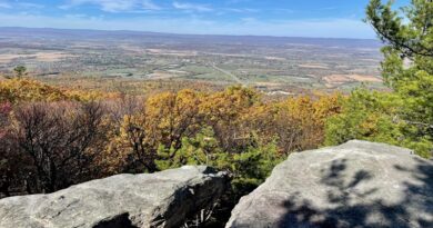
In a few more steps, you are at a flat northwest-facing viewpoint. To your right is a large rock outcropping.
It’s just right for scrambling to a higher view. You’ll also see a brown trail sign indicating that the summit (and an actual viewing platform) is 50 yards away.

At the top, there’s plenty of room for everyone to enjoy the views. As a bonus, I had four bars with AT&T at the summit (I had no service on the hike to the top).
I noticed quite a few buzzing flies at the summit too, so be sure to bring along insect repellent.
Re-trace your steps to the parking lot but watch your footing since the trail is quite steep and it can be easy to slide on small gravel rocks on the way down.
I measured an elevation gain of 669 feet, but it felt like more given the relatively short distance to the top.
#2: Hawksbill Loop Hike
From the Hawksbill Gap parking area, select the trail that leads off to the right for the 2.8-mile loop hike.
This blue-blazed hike is more rocky to start and begins with a mild descent.
Shortly, a trail marker appears as the trail intersection with the Appalachian Trail. Turn left here to pick up the southbound route.

From here, this shady trail narrows and begins to ascend. In summer, it’s quite green, with lots of low-growth plants and ferns along either side of the trail.
While the Hawksbill Summit Hike has a steady incline to the summit, the Hawksbill Loop Hike takes a different approach.
Instead, you’ll notice a mild ascent, then a flat section, then a mild ascent (repeat, repeat). Look to the right and you can see the mountains through the trees.
In late-fall, you can see the mountains much more clearly. At the .45-mile mark, you’ll notice a steep and massive boulder field on the left-hand side of the trail.

In a few more steps you’ll reach a second open boulder field, then a third section of mid-size rocks.
By the third or fourth one you actually need to scramble across them to reach the dirt trail on the other side. Watch your footing as some rocks can be loose.
From here, you re-enter the shady forest and begin to go downhill for a short time. At the 1.1-mile mark, the trail splits.
Take the trail on the left-hand side, the Salamander Trail, which leads you to the summit. Again, you will encounter a mild incline, then a flat section, repeat.

At the 1.75-mile mark, the trail opens up on the left-hand side to a small, rocky viewpoint that is quite beautiful.
In another few steps (.05-mile), there’s another opening to a viewing area on the left-hand side of the trail. Both are good warm-ups for the main attraction.
In a few more steps, the trail connects with the Lower Hawksbill Trail (the out-and-back trail for the Hawksbill Summit Hike).
Turn left, then in a few more steps, turn left again at the trail marker and the Byrds Nest Shelter #2 comes into view.

Savor the views from different areas of Hawksbill Summit, including the Hawksbill Viewing Platform. While there, look for the sundial built into the stone wall.
It’s 1.95 miles to the summit. To return to your car, re-trace your steps to the first trail marker, then turn left to descend the steep, rocky Lower Hawksbill Trail.
I measured an elevation gain of 771 feet, but the trail felt less challenging than the Hawksbill Summit Hike, which had a gain of 669 feet.
I imagine this is because it’s just .8 mile to reach the top on the summit hike, but 1.95 miles to the top on the loop hike.

#3: Upper Hawksbill to Hawksbill Summit
From the Upper Hawksbill parking area (a larger parking area than the Hawksbill Gap parking area, by the way), ascend the shaded 2.1-mile out-and-back trail.
This route takes you along the Upper Hawksbill Trail to the Hawksbill Summit.

This hike begins from a higher elevation point, nearly 300 feet higher than the start of the previous two hikes to the summit.
However, there is still an elevation gain of 489 feet to reach the top on this hike. In some sections, you can definitely feel the burn.
Much like the loop hike, this dirt and gravel trail to the top has mild inclines, then flat sections. At the .65-mile mark, you’ll see a trail marker.
Here you’ll want to veer right on a mostly gravel trail. This section is quite steep, so be ready for a slog up the hill.

By the .95-mark, you’ll see another trail marker. Continue to the right to stay on the path to the summit. At the one-mile mark, you’ll see one more trail marker.
This is where the trail connects with the Lower Hawksbill Trail. Turn left and Byrds Nest Shelter #2 comes into view. The viewing platform is at the 1.05-mile mark.
Re-trace your steps to the return to the parking lot, turning right at the first trail marker, then left at the second trail marker to descend the relatively steep hill.

Wrap-Up Notes
Certainly, there are pros and cons to each route to the Hawksbill Summit. However, if I had to choose one, I would opt for the Hawksbill Loop Hike.

Of course, the loop hike was longer both in distance and time hiked (it took me 1 hr, 20 mins to hike – the other two hikes each took me 50 minutes).
However, I liked that the elevation gains were more moderate and the scenery was more varied. The boulder field is very cool and unique.
There’s no question that there are certain sections of the two out-and-back hikes that are unmercifully steep.
They were short, but you will need to catch your breath, no matter how fit you are. On the loop hike, I never felt out of breath on the way to the summit.

For post-hike refreshments and restrooms, Big Meadows Wayside is at mile marker 51. It’s a very short drive from both parking areas.

Erin Gifford has completed more than 300 hikes in Virginia. She is also the author of three hiking guidebooks from Falcon Guides. Need help finding a hike? Check out the Trail Finder feature or send Erin an email at [email protected].